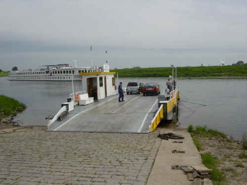
Home Introduction Italy Germany Places Nearby Kommando W/610 Sources & Links Guest Book Contact me

                         Stalag IV-B photos

My guide to visiting:

Stalag IV-B, Muhlberg, Germany May 2004

Muhlberg
Stalag IV-B
Neuburxdorf Cemetery

Muhlberg

The town sits on the east bank of the River Elbe approx 45kms/28 miles east of Lepzig. If you approach it on the main B182 road from Torgau (from the north) or Riesa (from the south) please note that you will have to use a little car ferry to cross the river Elbe – all 27.5 metres of it – cost €1.50. Once across, follow your nose for about 1km/¾ mile to the town. But if you intend to return by this route please make a strong mental note of where the road from the ferry enters the town proper or ensure you get a town map!  The street you will want is Am Storchennest which is the exit road from the town towards the west and the German for this river ferry is Elbfahre.  It's easy to get lost here!

Muhlberg_Elbe_ferry_small-1.JPG (17114 bytes)    Muhlberg_centre-1.JPG (21961 bytes)    Muhlberg_museum_small-1.JPG (23703 bytes)    Muhlberg_town_hall-1.JPG (21511 bytes)        

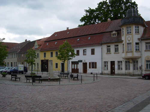
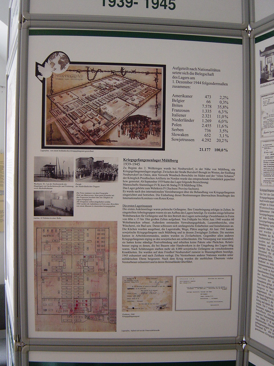
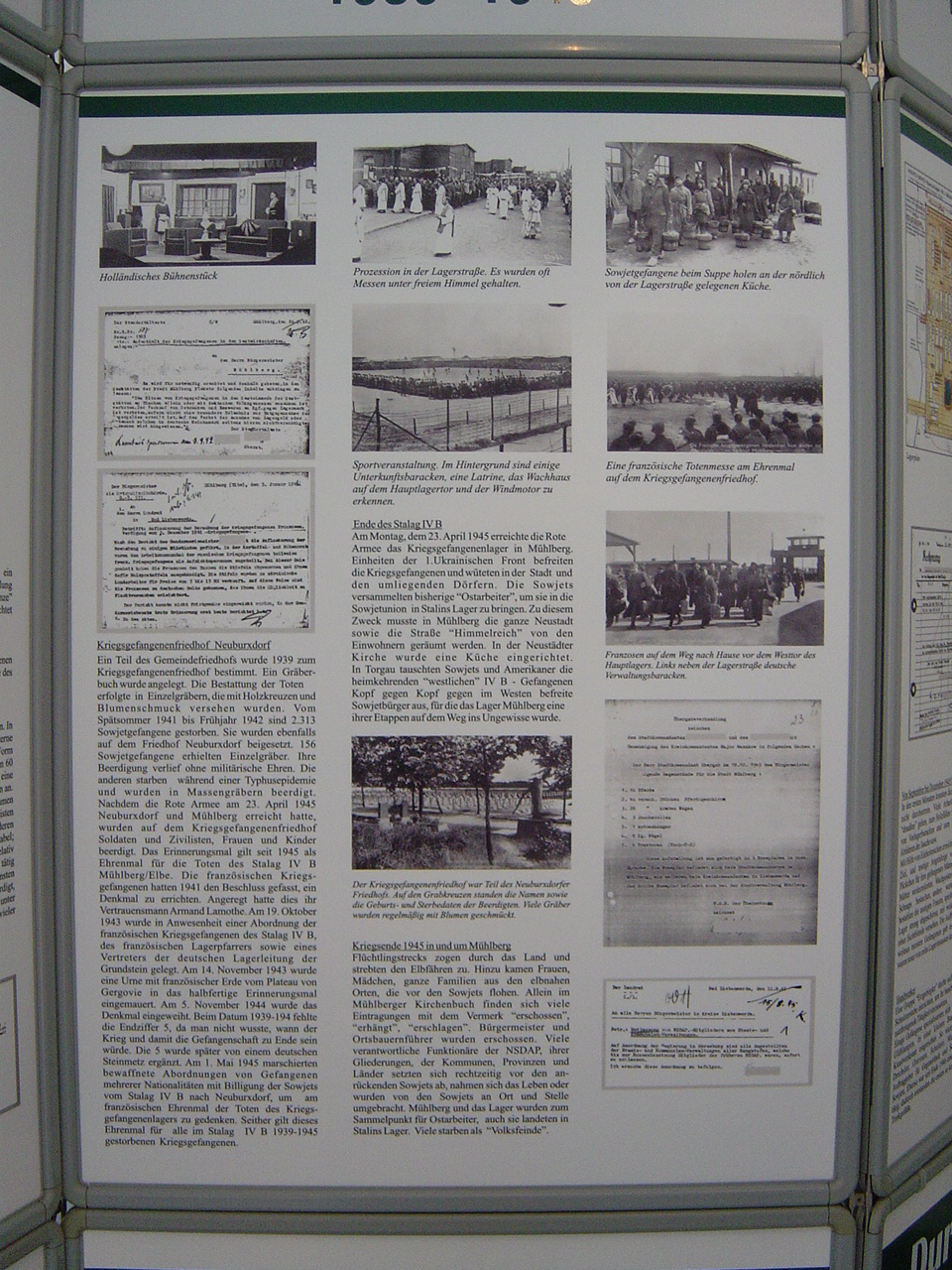
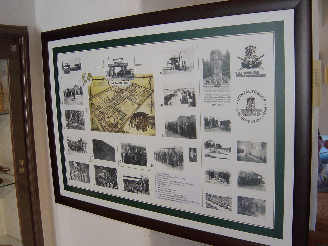
MUHLBERG: Ferry             Central square                   Museum                         Town hall                                                     

Muhlberg is a sleepy little market town with cobbled streets straight out of a Grimm's fairy tale. The museum, which doubles as the tourist information office, is on Klosterstrasse and is signposted. The exhibits are mainly concerned with the town's long history but there are three display boards with details (in German only) and plans, photos etc of the PoW camp. There are also some artefacts from the Stalag on show and some typed historical information (in English) provided by the camp research and preservation group which operates from the museum. Opening hours can be "flexible" so it might be worth contacting them first to confirm.

Tel: (035342) 70687

Email: info-museum-muehlberg@t-online.de

Or see the town's website at: http://www.muehlberg-elbe.de/verzeichnis/visitenkarte.php?mandat=63856

The latest times I have seen are:

May–Sep: 10am–5pm (closed 12–1) Mon–Fri
1pm–5pm Sat & Sun

Apr, Oct & Nov: 10am–4pm (closed 12–1) Mon–Fri

Dec–Mar: 10am–4pm Mon–Fri

Muhlberg museum display 1.jpg (600950 bytes)    Muhlberg museum display 2.jpg (592759 bytes)    Muhlberg museum display 3.jpg (604998 bytes)

Display boards at Muhlberg museum
Back to Top

Stalag IV-B

The site of Stalag IV-B is about 8 kms/5 miles northeast of Muhlberg situated to the west of the railway line through Neuburxdorf, south of the Muhlberg–Bad Liebenwerda road, and east of the Burxdorf–Altenau road. There are two ways to get there and three entrances to the site. All are signposted with brown tourist signs saying "Kriegsgefangenerlager" (PoW camp).

1. Leave Muhlberg to the north on the road signposted Bad Liebenwerda (and possibly Burxdorf). At the village of Burxdorf turn right onto the road for Altenau. Take the left fork and left again at the subsequent cross-roads where the western entrance to the camp is signposted straight ahead.


2. Alternatively, leave Muhlberg to the east on the Altenau road. At the village of Altenau turn left towards Burxdorf. Subsequently turn right onto the road signposted for the camp again to the western entrance.


3. If you want to do a little off-road driving you can also approach from the north by a dirt track across the fields from a turn off the road between Burxdorf and Neuburxdorf. This leads to the cemetery at the northern edge of the camp from which you can walk into the camp proper.

Originally built to hold 10,000 prisoners the camp is a large rectangle measuring about 1 kilometre/1100 yards by 500 metres/550 yards with a central avenue running east–west dividing it into two. From the western entrance you can only drive to the midway point. To drive along the eastern section you must exit the camp and keep turning left (four times) until you come to the eastern entrance. If you are mobile enough though, you can just park in the centre and walk to all points. It is worth going first into the cemetery area where there is an information board and a booklet (in German only) with a plan of the camp and the local roads on the back cover.

The camp is now covered by dense forest with no more than signs indicating what buildings were in each part. The only ruin of a building remaining is the latrine block, which seems ironic now. There are several carved stones in memory of the inhabitants who did not survive its horrors explaining what the site was. There is also a small display of photographs of the camp during the war. Understandably the Germans have made it clear that as well as being a PoW camp for Allied prisoners from 1939 to 1945, it became a Russian controlled "gulag" for Nazi PoW after the Russians occupied this area at the end of the war. Nearly 7,000 Germans died here between 1945 and 1948.

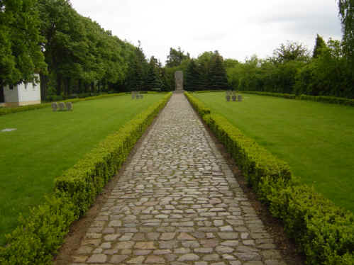
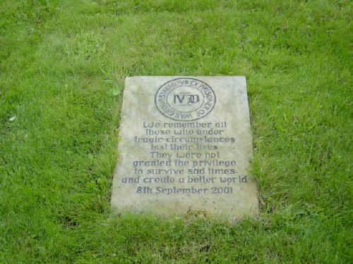
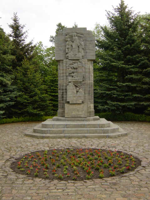
To see a comprehensive set of photographs from my trip, please click on the navigation button in the left margin or click here

Back to Top

Neuburxdorf cemetery

Neuburxdorf village is adjacent to the Stalag about 6kms/3¾ miles northeast of Muhlberg. Amongst its few modern houses is the cemetery containing a monument to all the PoW who died in the camp and memorial tablets in English, French, Italian and Hebrew.

Neuburxdorf_PoW_cemetery_2_small-1.JPG (22889 bytes)    Neuburxdorf_PoW_cemetery_3_small-1.JPG (27143 bytes)    Neuburxdorf_PoW_cemetery_4_small-1.JPG (41127 bytes)    

NEUBURXDORF: Cemetery
Back to Top
 (Last updated 23 August, 2009)

wordpress blog stats